Wastershed Tour or Field Trip?
Submitted by Matt Pollard on Wed, 2017-06-07 00:00
I *love* exposing my students to their local watershed. Students quickly grasp the connection between their daily activities and the quality of our water, henceforth, their surroundings. I've done this several ways: a field trip where we go up stream and discuss the impactors in our watershed and virtually through Google Maps/Earth. And I've done this as a class (field trip) and in small groups (virtually).
The Watershed Tour is a super valuable lesson and should include early in your water units.
There are a few things you should have on-hand to do this lesson:
- Topo Maps (7.5 minute) of your area. You can download high-res USGS topo maps for free (from the USGS' web page) and then print (in color if you can) and laminate them in 11x17. Using white-board markers, students then can outline the watershed. I will mix it up and give students neighboring communities and have them map their watershed too, discussing how the water drains differently in the different communities. Note- this really only works if you are in an area with rolling hills and/or mountains. Note sure how it'd look in the flat areas of the state- sorry! Oh yeah- this is a good place to bring up HUC numbers and have them try to figure out their HUC Address
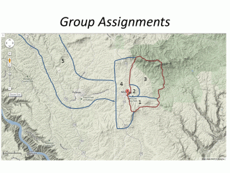
- Electronic Deceives (laptop, Chromebook, iPads, etc.). Once students have a grasp on their watershed as a whole, I find a lot of value in taking a virtual tour- this is where people with a keen knowledge of the area really stand out. To do this, I break up the watershed into a handful of different regions and then each groups is assigned to judge the health of their regions, being sure to discuss sources of pollution, straightening / canaling of the stream(s), and mitigation / corrected / restored areas. See the photo of my local watershed (Moscow and South Fork of Paradise Creek) to how I've broken up the assignment. Again, this can be done from the comfort of the classroom, however offering extra credit may entice some students to drive their regions, snap photos and discuss.


Comments
This information is so
This information is so helpful Matt! I love that you take your students outside the classroom to be able to experience the Portneuf themselves!
Love this!
Matt! Thank you so much for sharing your ideas and suggestions on how to make this work in the classroom. I definitely want to try this. If you have an electronic copy of this lesson plan, you should add it to the resource section. Thanks again for sharing, it's extremely helpful!
Uploaded under "lesson plans"
I uploaded two basic powerpoints of photos that I use when introducing the watershed and the watershed tour.
Great idea
I love the ideas you have to make learning fun and interactive. Thanks!